IAMSAR Search Patterns
IAMSAR Search Patterns Explanation with Sketches.
EXPANDING SQUARE SEARCH:
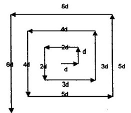
- Most effective when the location of the search object is known within relatively close limits.
- The commence search point is always the Datum Position.
- To be used by a single ship during a search.
- Often appropriate for vessels or small boats to use when searching for persons in the water or other search objects with little or no leeway.
- Accurate navigation is required.
- The first leg is usually oriented directly into the wind to minimize navigational errors.
- All course alterations are of 90O.
- Two
first two legs will be of same length ‘d’. ‘d’ will depend upon the
visibility and the height of eye of the lookouts and the swell and sea
height.
- Legs 3 and 4 will be a length of 2d.
- Legs 5 and 6 will be a length of 3d.
- Legs 7 and 8 will be a length of 4d.
SECTOR SEARCH:-
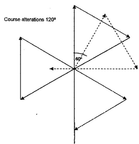
- Most effective when the position of the search object is accurately known and the search area is small.
- Used to search a circular area centered at the datum.
- Can be used by only one craft at a time at a certain location.
- An aircraft and a vessel may be used to perform independent sector searches of the same area.
- A suitable marker may be dropped at the datum and used as a reference point.
- The commence search point is where the ship or aircraft enters the area to be searched.
PARALLEL SWEEP (TRACK) SEARCH:-
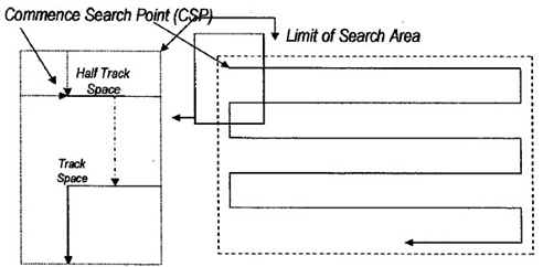
- Used to search a large area when the location of the search object is uncertain.
- Most effective over water or flat terrain.
- Usually used when a large search area must be divided into sub-area for assignment to individual search facilities on-scene at the same time.
- The commence search point is in one corner of the sub-area, one-half track space inside the rectangle from each of the two sides forming the corner.
- Search legs are parallel to each other and to the long sides of the sub-area.
- The main legs indicate the direction of drift.
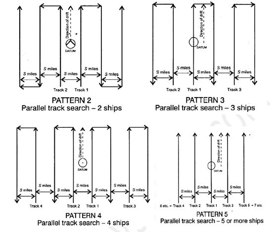
Multiple vessels may be used as shown opposite:
- Parallel sweep: for use by two ships.
- Parallel sweep: for use by three ships.
- Parallel sweep: for use by four ships.
- Parallel sweep: for use by five or more ships.
TRACK LINE SEARCH (TS):-
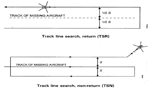
- Normally used when an aircraft or vessel has disappeared without a trace along a known route.
- Often used as initial search effort due to ease of planning and implementation.
- Consists of a rapid and reasonably thorough search along intended route of the distressed craft.
- Search may be along one side of the track line and return. in the opposite direction on the other side (TSR).
- Search may be along the intended track and once on each side, then search facility continues on its way and does not return (TSN).
- Aircraft are ‘frequently used for TS due to their high speed.
CONTOUR SEARCH (OS):-
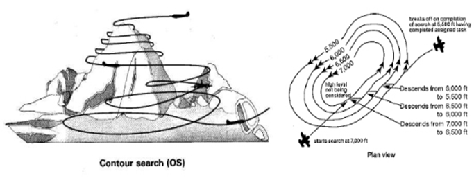
- Used around mountains and in valleys when sharp changes in elevation make other patterns not practical.
- Search is started from highest peak and goes from top to bottom with new search altitude for each circuit.
- Search altitude intervals may be 150 m to 300 m (500 ft to 1,000 ft).
- The aircraft may make a descending orbit away from the mountain before resuming the contour search at the lower altitude.
- The aircraft may spiral downwards around the mountain at a low but approximately constant rate of descent when there is not enough room to make a circuit opposite to the direction of search.
- If the mountain cannot be circled, successive sweeps at the same altitude intervals as listed above should be flown along its side.
- Valleys are searched in circles, moving the centre of the circuit one track spacing after each completed circuit.
CO-ORDINATED VESSEL-AIRCRAFT SEARCH PATTERN:-
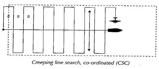
- Normally used only if there is an OSC present to give direction to and provide communications with the participating craft.
- Creeping line search, co-ordinated (CSC) is often used.
- The aircraft does most of the searching, while the ship steams along a course at a speed as directed by the OSC so that the aircraft can use it as a navigational checkpoint.
- The aircraft, as it passes over the ship, can easily make corrections to stay on the track of its search pattern.
- Gives a higher probability of detection than can normally be attained by an aircraft searching alone.
- Ship speed varies according to the speed of the aircraft and the size of the pattern.
- The relationship among the speed of the surface facility, the aircraft’s speed, the track spacing and the length of the search legs is defined by the following equation:
Vs = (5 x Va)/ (L + 5)
Where,
- Vs is the speed of the surface facility in knots;
- S is the track spacing in nautical miles;
- Va is the aircraft’s true air speed (TAS) in knots, and
- L is the length of the aircraft’s search leg in nautical miles.
Comments
Post a Comment